
Valle de la Luna
2 December, 2007, 02:04 pm in "Bolivia"
 A thick layer of clouds had capped the valley, covering La Paz. It had rained the night before, but we'd planned on visiting the Valle de la Luna. The weather is so changeable, no matter how it starts out in the morning, at some point it will probably rain. We waited for a while for a microbus containing one of the numbers listed on a brochure we got from the tourist info center. Eventually we gave up, walked further down to a main rotary and looked for any mini or microbus with the word Mallasa on it. We witnessed a fender bender and a few narrow misses and finally caught bus 43 which went to Mallasa but wasn't mentioned in the brochure. The bus was packed which made sense since it was probably the first bus in an hour going to Mallasa. Unable to see much out of the windows, we were blindly carried off to the hills. Fortunately the driver guessed that we were headed to the Valle de la Luna and let us know when we got there.
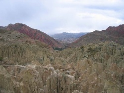
 From La Paz, we had been able to see some of the types of rock formations that make up the Valle. A lot of the hills around the city have odd eroded rock pinacles.
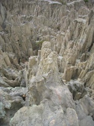
The Valle is up a hill from S. La Paz. It is an area full of pinacles made up of something between mud and rock. Though you can see the pinacles all around the area, the Valle site has paths constructed so one can walk around, above and between the pinacles. Signs point out formations like the "Good Grandfather" and the "Lady's Hat".
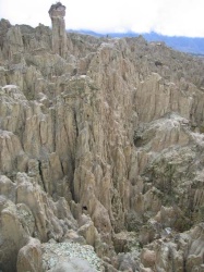
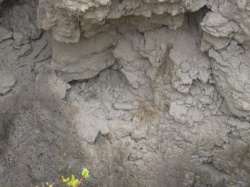
It started raining while we were there and the path became muddy. In one area, the trash people had thrown down had become completly covered with mud which had dripped from the pinacles above.
In the distance, the red hills reminded me of Utah.
After doing the circuit we walked down the hill into town. The ceramics workshop Rowshan wanted to see was closed so we looked around the town then walked back up the hill. We decided to hike a trail called the Sendero de Aguila. It followed the edge of one of the red mountains and was in an area, Amor de Dios, which rumor has it was an area where Che Guevara hid out in 1967.

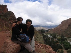
Walking down toward the path, we cut through a cactus park. The path was above a river and had beautiful views of mountains on the other side, and swanky houses below. The sun had come out by the time we got to the mirador which looked out over the city. We couldn't get to the mirador because the path up it had been washed away. We walked down into the city and caught a microbus back to the center, stopping in the swanky bar/embassy area--not very lively since it was a Sunday afternoon.
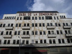
As we walked up to check bus times to Cochabamba, we noticed a derelict building with all the windows broken. At the top in big letters was "Casa De La Democracia" We found this very ironic.
Comments
- Comments
Powered by My Blog 1.69. Copyright 2003-2006 FuzzyMonkey.net.
Created by the scripting wizards at FuzzyMonkey.net..
(Code modified by Rowshan Dowlatabadi)
Created by the scripting wizards at FuzzyMonkey.net..
(Code modified by Rowshan Dowlatabadi)